

John Rock is a well-loved destination for many Pisgah goers for its beautiful views and quieter scene than neighboring Looking Glass Rock. At the top of the mountain you can relax on the exposed face of John Rock and take in the view of the main spine of Pisgah Forest. There are many backpacking campsites scattered around the trail and streams border the mountain on both sides making this a great destination for an easygoing backpacking trip. Whether you’re going for a day hike or making a stop on a longer excursion, John Rock is definitely worth the time.
At its most basic John Rock is exactly what the name implies: a rock. However, in more scientific terms, John Rock is a roughly 200 foot tall granite face on the side of the mountain that has been exposed over hundreds of years of erosion. The rock reflects the age of the Appalachian mountains as a whole-- the oldest mountain range in North America. While most of the surrounding mountains are blanketed in thick soils and forests, centuries of storms scoured the face of John Rock until it became the sheer cliffs we see today.
The Route
This 5.25 mile loop features forest, waterfalls, and a summit. I found the trail to be a satisfying mix of uphill climbs and more leisurely walking. There really is no ugly part of the route, the entire loop sports either gorgeous views or lush forests. All in all, a recipe for a great day hike.
The trailhead starts at Pisgah Center for Wildlife Education, aka the fish hatchery. Here, you will find ample parking, a water fountain, and sometimes bathrooms (Don’t count on them being open though). Cat Gap loop follows Davidson River to the base of the mountain. From here it is a steep climb to the top of John Rock. About halfway up the mountain, take the spur marked "John Rock trail" for a more direct route to the summit. On the way back down follow John Rock trail over the top of the mountain and then turn right to rejoin Cat Gap loop and continue back to the fish hatchery.
Click here to see the trail map.
Getting There
Like many trails in the area, the route to John Rock is predominated by lush, established forests of Tulip Poplar and Hemlock trees. It starts off with a level walk beside Davidson River but then quickly slopes into an uphill climb to John Rock. This one had my calfs burning but it's also super pretty--some consolation while you're panting up a mile of steps.


When I got to the top, I emerged out of the trees onto a smooth rock face that drops off to the valley floor, leaving sweeping mountain views in the air where the ground should have been. I stepped out onto the rock face along with my fellow hikers; a few couples and a boy scout troop. It feels incredibly ironic to stand in such an otherworldly, wild feeling spot while listening to a group of pre-teen boy scouts argue about who should get the next cell phone upgrade. I couldn't help laughing to myself, remembering a quasi-nightmare from a few nights ago where a boy scout troop invaded my campsite in the middle of the night and started making smores. Truly a solo camper's nightmare.


Despite the company, the top of John Rock is one of those places where it feels like you could stay for hours. I stretch out on the warm rock with my thermos of instant coffee and have one of the best morning coffee breaks ever. Today the view is hazy because of the thick mist. It feels like I literally climbed straight into the clouds and it is interesting to see the world from this new perspective. The mountains around me pop in and out of the clouds from the forest floor. Looking Glass Rock is the most striking peak. It's a monolith with an exposed face that faces John Rock on the opposite side of the valley. In the hazy mist the grey rock reminds me of an elephant rising out of the green forest. No, wait, it's technically a monolith, that sounds more ancient...like a woolly mammoth. Yes, Looking Glass is like a woolly mammoth rising out of the forest.


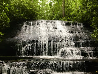
With that interesting but only half-lucid sounding thought in my head I get up and start off down the mountain. The route off of John's Rock is super fun (way more than the calf-burning climb to the top). At first, you walk straight over the top of the mountain. This is my favorite part of the trail in winter because you can see off of both sides through the trees and it feels like you are walking on the head of some sleeping giant. Then you hit the saddle and cruise the rest of the way down through a wide hollow next to a small stream. I always keep and eye out for waterfalls in this section. There are a few cascades with rock slabs at the bottom where you can wade in the shallow water and walk right up to the falls. Especially good if you're hot or in need of a shower (I was both).


Great review Cami! A late night boy scout invasion does sound like a nightmare!
ReplyDeleteHaha ikr!
DeleteThis comment has been removed by the author.
ReplyDeleteNoah Guthrie:
ReplyDeleteThank you for making this post! I appreciate your describing the journey to us and sharing your photos, from the rock face to the waterfalls. Also, I'm curious what the knobby plants in that ninth picture are. I'm not sure if I've ever seen them before.
Either way, it sounds like a great hike!
Thanks, I'm glad you enjoyed it! To be honest, i've been wondering about that myself. They look like tiny cedar trees to me but I'm pretty sure that's not what they are : ) I'll let you know if I figure it out.
Delete